I was introduced to the idea of a Thoreau Walk by reading Cape Cod, a collection of essays by naturalist writer Henry David Thoreau on his trips to Cape Cod in the late 1840s and early 1850s. Thoreau, a native of Massachusetts, is best known for his book Walden. I am not a big fan of naturalist writers in general, and specifically Thoreau. I have often wondered why people take medication to sleep at night when they could just take Thoreau. A few pages of Walden almost always guarantees me a sound sleep. But I make an exception for the book Cape Cod. It is like traveling back in time to see what the Cape was like 170+ years ago. Cape Cod was so rural in those days that Thoreau had to take a stagecoach from Sandwich to Orleans - staying in Sandwich for such a short time he said he only had “half a sandwich” (that’s naturalist humor for you). With Orleans as his base, he walked up and down the seashore multiple times, both the backside (the side facing the Atlantic) and the bayside (the side facing Cape Cod Bay). The book chronicles the flora, fauna, landscapes, people and culture of Cape Cod in the 19th century, freezing in time a long gone era.
Due to the creation of the Cape Cod National Seashore in 1961, you can replicate Thoreau’s 28 mile hike from Eastham to Provincetown today. I did it for the first time this month, and thought I’d pass on what I learned to anyone else interested in making the journey.
The Logistics
The walk is 28 miles, all on the beach, and walking almost continuously on a slight incline. While your pace will vary based on the softness of the sand, you will cover about a mile every 20 minutes. The entire trip can be done in about 9 hours of walking with no breaks - but most people split this over two or three walks to allow time to enjoy the scenery. The Cape Cod National Seashore is open from 6 AM to 11 PM, and does not allow camping or fires on the beach. Rangers patrol the entire length of the beach, so it is best not to violate these rules. Also, given the aggressive coyotes in this area, you should think twice about being on the beach at night.
While the Cape Cod National Seashore is really one continuous beach, not all areas are impacted the same way by the tides. For our September 2021 journey, the areas north of Marconi Beach and around Ballston Beach were washing over at high tide. To minimize the risk here, we talked to rangers at the Salt Pond Visitor Center in Eastham, since they have the best knowledge of the dangerous areas. This will of course change each season based on the impact of storms. But you definitely do not want to get caught between a flooding beach and a 70 foot vertical bluff. One other tip to pass on: by choosing a date between a new and full moon, you can minimize the risk of flood tides.
Whether you do your Thoreau Walk over one or multiple days, you will need to arrange a dropoff and pickup. My niece was kind enough to volunteer to be our personal driving service. When it comes to arranging for pickups, bear in mind that while cell coverage along the seashore is much better than in previous years - ironically due to emergency services for shark attacks - you will still lose connectivity in several places. We turned on location tracking so my niece could watch us remotely, and gave her estimated times for pickups that we would update throughout the walk.
You will also want to consider when to do the walk. The choice of month will impact the availability of facilities and the climate. We chose to do our walk in September when the temperatures were cooler. While I am sure you can do it any time, I’m not sure I would want to do it during a hot stretch in July or August. We also got on the beach before dawn to allow us to watch the sunrise and do the majority of our walking during the cooler hours. From Labor Day through the end of September - a.k.a. “local summer” - beaches will often not charge for parking midweek. But you can also expect limited facilities on some of the town run beaches during September.
It’s worth noting that from Coast Guard Beach in Eastham to Race Point in Provincetown there are five beaches run by the National Park Service (NPS) - Coast Guard, Nauset Light, Marconi, Head of the Meadow, Race Point - and ten run by local towns. You will find the facilities at NPS beaches to generally be better than town run ones, with actual restrooms instead of portable toilets, and often with water filling stations. The exception here is Head of the Meadow Beach, which had no facilities open in September. A little planning around restrooms can make for a more comfortable trip.
What To Bring
We brought backpacks, a camera, flashlights, snacks, water, a first aid kit, and sweatshirts. We actually carried a lot more on day 1 that we ditched by day 2 - e.g. raincoats, binoculars, battery packs, towels, swimsuits. My only advice is to travel as light as you possibly can and bring extra water. I was surprised how much water I consumed on the walk.
Some people walk in sneakers and others go barefoot. I tried both and found sneakers were much easier than walking barefoot for most sections of the beach. As a general rule, the beach will be firmer closer to the water when the tide is falling, since the drying sand is compacted a little bit more. But be prepared for some tough stretches of beach that requires trudging through some very soft sand.
Our Trip
If you are just interested in the facts, you can stop reading here. But if you are interested in learning more about the journey, I included my travel log below:
I did my Thoreau Walk on the weekend of September 11, 2021 with my sister Kathy and my wife Kristin. We did the walk in two days, with about 14 miles of walking each day. Day 1 brought us from Coast Guard Beach in Eastham to Ballston Beach in Truro. Day 2 took us from Ballston Beach to Race Point Beach in Provincetown. We did the walk in about 12 hours, which included time for taking breaks and enjoying the scenery. My sister was recovering from a broken ankle, so I originally had spread the walk over three days, but she was feeling great on day 1 and wanted to push on.
Just like Thoreau, our journey started in Orleans: in my case, at my house, and in Thoreau's at the Higgins Tavern. The main building of the inn that Thoreau stayed in 172 years ago can still be seen today at the Olde Tavern Motel & Inn on Route 6A - although it was located acrossed the street in Thoreau's day.

Day 1: Coast Guard to Nauset Light Beach (~1.2 miles)
Our niece dropped us off at Coast Guard Beach in Eastham. Coast Guard is a NPS operated beach, and is one of the most beautiful on the Cape. It was dark and rainy when we arrived, and we wore raincoats for the first hour before the weather started to clear. We could see the white coast guard station further up the hill as we started walking north. The tide was still falling, and we had some firm sand to walk on. The bluffs behind the beach started low but gradually got higher. Small trees and shrubs lined the tops, appearing to barely hold on as erosion ate away at their topsoil and exposed their roots. The beach was wet and foggy for much of the morning.
Nauset Light Beach has one of the most iconic lighthouses on Cape Cod. If it looks familiar to you, it is for a good reason: in addition to being one of the most photographed lighthouses in New England, it is also on every bag of Cape Cod potato chips.
The Cape Cod National Seashore was born out of a movement in the 1950s to preserve our national seashore. The rapid post-war development in the US was turning some of our most beautiful seashores into Miami Beaches, complete with big hotels and overdeveloped strips. The US Congress came up with a solution: preserve some of these remaining seashores as national parks. Unfortunately since the majority of the land Congress wanted to preserve on Cape Cod was actively being lived on, this was not like the creation of any previous national park in our history. But through the hard work of lots of people, a solution emerged that became known as the “Cape Cod Model.” This compromise allowed existing private property owners to live within the park with restrictions while the federal government acquired the remaining lands to prevent future development. It also gave the local towns some influence over governing the park. President Kennedy signed the legislation for the Cape Cod National Seashore in 1961, preserving 43K acres of land that includes seashore, estuaries, ponds, forests and dunes. The result: we can walk the same 28 miles Thoreau did 172 years ago and see pretty much the same scenery he did.
Day 1: Nauset Light to Marconi Beach (~2.4 miles)
The weather cleared as we were headed north, but big waves continued to crash into the shore. The coastline here had a lot of sandbars, resulting in sets of waves starting much further off shore for some sections of the beach. Seals were in the water almost continuously throughout the walk, and they often stopped to stick their heads out of the water to watch us, curious what we were doing on the beach at such an early hour. The cliffs along the beach varied in size and shape, but were generally a little more rounded here, as though they were eroding slower than other areas of the seashore.
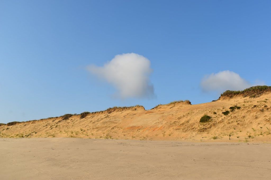
A little over halfway from Nauset Light to Marconi we crossed from Eastham into Wellfleet. As we neared Marconi Beach, we started to see some areas that were clearly more impacted by erosion, with steep bluffs that were crumbling under the relentless force of the wind and water. As you walk, you will frequently see the remnants of former structure falling down the bluffs - e.g. foundations of houses, sidewalks, telephone poles, cables. It’s all a reminder that this seashore is always eroding - currently at an average of three feet per year, but substantially more in some areas. At Marconi, we climbed the high stairs to use the facilities, since these would be the last reliable ones we would see in a while. But the view from the top of the bluffs alone can justify making the trek up.

Marconi is my boys’ favorite beach on the Cape. The high bluffs and big waves always made for the best body surfing. That of course was before the growing seal population brought the great white sharks to the area. Now it’s common to have 30+ shark sightings near shore per week along the backside of the Cape. But as much as we all like to think of this as a new “problem” on the Cape, Thoreau said in Cape Cod that people didn’t swim on the Atlantic side due to sharks - and that was 172 years ago.
I’m glad to say that we managed to get through this area without any issues. The Atlantic can wash all the way to the bluffs on the north side of Marconi Beach. If you ever got caught there at high tide, I’m not sure what you would do, since there is no way to leave the beach without climbing 70'+ bluffs. Fortunately we planned this trip around the tides, so we were able to pass without any issues. One of the things many people don’t think about on Cape Cod is its location relative to the coast. The Cape sticks out 30+ miles into the Atlantic Ocean. To put that in perspective, imagine being on a boat 30 miles out to sea. Not only are you far away from civilization, but the climate and weather is much different than the mainland. It’s for this reason that the Cape is often a location for historic transatlantic events - e.g. Charles Lindberg flew over here on his way to France, the second transatlantic cable ran through Orleans, and this was the site of the first two-way transatlantic wireless communication. The latter accomplishment would give this beach its name - named after Guglielmo Marconi, the inventor of wireless communications. Marconi's original wireless array was once located here, where it would receive the first wireless transmission on the sinking of the Titanic. A plaque to commemorate Marconi and his invention still stands further up the beach.
Day 1: Marconi to White Crest Beach (~2.9 miles)
From Marconi we passed through Lecount Hollow Beach to White Crest. The color of the bluffs changed a little as we walked, with orange and yellow more common here instead of white. We also saw a lot of vegetation growing on the cliff. In Cape Cod, one of the locals tells Thoreau that when it comes to growing, the yellow sand has some life in it, but the white sand is completely dead.
You will pass many houses along here that are within a few years of falling into the ocean. They are located on the edge of the bluffs, in some cases barely hanging on. We saw one house whose back deck had partly fallen over the bluffs, with the edge of its roof held up with newly installed beams attached to the house base due to the absence of a back yard. We also saw some of the longest staircases I have ever seen coming from private homes - the longest stretching a good 100 feet.
Day 1: White Crest to Cahoon Hollow Beach (~1 miles)
I am sad to say but this is the closest I have been to the Beachcomber this year. For those who don’t know, the Beachcomber is a bit of a Cape Cod institution. It is a restaurant & bar located on Cahoon Hollow Beach that does not take reservations and is always packed. I can’t tell you how many times I have driven to the intersection at the top of Cahoon Hollow Road only to be turned away by the attendant due to lack of availability. The whole place has a Jimmy Buffett “Cheeseburger in Paradise” vibe, reminding me more of a Florida Keys bar than a New England restaurant. Unfortunately you need to pay $30 to park in the lot before you find out if you can get a table, so I usually only visit after Labor Day.
The actual building for the Beachcomber has an interesting story behind it. It is one of nine Life Saving Service stations built on the Outer Cape in 1897. The backside of the Cape became known as the “Graveyard of the Atlantic” due to the fierce winter storms. Over 3,000 ships have been sunk along this 50 miles of Atlantic coastline. Sailors who were fortunate enough to make it to shore would often die of hypothermia due to lack of shelter, food and water. To prevent this, a private organization installed basic shelters along the beach stocked with supplies. This eventually evolved in 1878 into the US Life-Saving Service, which brought manned stations along the Atlantic side of the Cape. The life savers worked in shifts, walking long stretches of beaches looking for shipwrecks. This service would eventually evolve into the US Coast Guard in the 20th century. You can watch the 2016 movie The Finest Hours if you want to see a great story about a real life Coast Guard rescue on Cape Cod in 1952.
Day 1: Cahoon Hollow to Newcomb Hollow Beach (~1.5 miles)
Newcomb Hollow Beach is named for John Newcomb, one of the people Thoreau met along his walk. He is forever immortalized as the 88 year old weathered Wellfleet oysterman who stayed up late at night with Thoreau to tell stories about shellfishing, his childhood, shipwrecks, his family and more. The John Newcomb House is still standing today, but is set back away from a rugged dirt road further inland and is not easy to find. We stayed on the beach and so did not pass near it.
One of my favorite parts of that story is when Thoreau tells the oysterman he is from Concord, and adds that the town is of “Revolutionary fame” just in case the old man hadn’t heard of it. But the man tells him that not only does he know where Concord is, but he heard the sound of the heavy cannons across Cape Cod Bay on that exact day in 1775 when he was 14. He also tells about seeing George Washington riding his horse in Boston after the British evacuation. This may have been one of the earliest examples of a local gently putting a slightly full-of-himself summer person in their place.
While the seashore we are walking changes every year due to erosion, it pretty much looks like Thoreau described it 170+ years ago - albeit about 500’ further west now due to erosion. But the same cannot be said of the land behind the beaches. When the first English settlers came to Cape Cod, they started clear cutting the forests to make room for their farms. By the time Thoreau walked here, there were very few trees on the Cape, and you had an unobstructed view of the water from almost any high point. But today the land has returned to its more natural state, with forests and shrubs and very few cleared areas. For this reason, there was a lot of debate during the creation of the Cape Cod National Seashore about what preserving “old Cape Cod” actually meant.
Day 1: Newcomb Hollow to Ballston Beach (~2.8 miles)
This last stretch was a little hard, due to us being tired and the softer sand. Walking on soft sand for this long is surprisingly difficult. Your heart immediately starts pumping faster, like you are on a light jog - but unfortunately the jog just never seems to end. We also were running a little closer to high tide than we planned, so ran into a few spots where the beach narrowed.
Not long after we left Newcomb Hollow we entered the third town on our way up the National Seashore: Truro. Truro is without a doubt the most rural town on the Cape. Thoreau claims this town had 1800 residents in 1849, whereas today it has grown to 2000 - a little more than one new person per year over 172 years. 😮 It is so rural that when my extended family rented a house there years ago, we used to pool our Dunkin Donut orders each day since the only one was over 25 minutes away. If that does impress you, you are clearly not from New England. I like to think that having a Dunkin within 5 minutes of you at all times is a God given right here.
Ballston Beach is in the Pamet Area River Valley, which contains one of my favorite hikes: the Pamet Area. This area was created from the catastrophic collapse of a glacial lake that existed 18,000+ years ago. It’s a reminder that Cape Cod was created during the last Ice Age, when an ice sheet covered this entire area with over two miles of ice. The elevation of this area is so low that Nor’easters have pushed rain and water all the way from the beach to Route 6, almost 1.5 miles away.
You can’t see it from here, but a little further up is one of the many kettle ponds on Cape Cod. There are over 360 of these on the Cape. They were formed when large chunks of ice fell off the retreating glacier and made a deep imprint in the land. If you get a chance, you should really go on a hike in the Pamet Area. The nearby hills give you a great view from above of the Pamet River Valley, Ballston Beach, the kettle ponds, and the rolling hills around this area of Truro. It is truly a special place.
Day 2: Ballston to Longnook Beach (~1.7 miles)
We decided to switch up our plans a little this morning. Originally we had planned to hit the beach at Ballston Beach and walk while the sun was rising. But my niece wanted to see the sunrise this morning too, so we decided to climb up a nearby hill called Bearberry Hill, which looks down on Ballston Beach. This next section of the walk will include some of the most remote hiking of the trip. You will pass by the remnants of an Air Force station along the way, with an operational air beacon still visible from the beach.

While most of the histories of Cape Cod start in 1620 with the arrival of the Pilgrims, this area has been inhabited for at least 12,000 years. The full human history of this area may never be fully known though, since the seas have risen over 450 feet since the last ice age, covering much of what was once was habitable land. But we know for sure the Nauset Indians lived here at least since 3000 BCE. They were part of the Wampanoags, an Algonquin tribe that inhabited southeastern Massachusetts. They were a peaceful tribe that farmed and fished these lands for thousands of years. You still see their village names used all across the Cape - e.g. Namskaket, Mashpee, Pamet, Poponesset.
The Nausets were likely the first people to have contact with Europeans in the 15th and 16th centuries. Due to the Cape’s location 30+ miles off the coast of Massachusetts, it was a common place for ships to anchor for repairs and supplies. A map from an early 1604 journey by Samuel de Champlain shows that the Cape likely was thickly settled in the first century after first contact, but had become sparsely populated by the time of the Pilgrims. The lack of immunity of the Native people to the diseases brought by the Europeans - e.g. smallpox, measles, the flu - allowed it to roll across their lands like wildfire. When the Pilgrims found empty villages and plowed fields in 1620, they assumed this was due to the "providence of God." But what they were really seeing was the remnants of a great pandemic that decimated entire villages.
Day 2: Longnook to Head of the Meadow Beach (~1.3 miles)
You will pass from Longnook through Highland and to Head of the Meadow Beach. If Cape Cod is shaped like an outstretched arm, this section of the beach will bring you past the bend in the wrist. When we started, we saw in the distance a bluff that we needed to walk around, but no matter how long we walked it didn’t seem to get any closer. It was with great relief when we finally turned the corner and knew we were in the final stretch of the Cape.
I have to thank my mother for my love of the Cape. After her six kids grew up and moved away, she began coordinating annual summer vacations as a reason to bring her family back together. While she spent her entire life in Central New York, I think she was a New Englander in spirit if not geography. She was passionate about travel, food, people and new experiences. For our first vacation with our extended family, she chose a small house on Cape Ann, where the biggest memory centered around me sinking a sailboat and being towed back to shore. For our second year, she chose a house in the middle of New Hampshire, where everyone remembers the constant rain and the soggy basement. For our third year she chose a small place in West Dennis, after which we were hooked on the Cape and with one exception never again looked anywhere else. Even as her family swelled to include six in-laws and 16 grandkids, she continued to rally us to get together on Cape Cod. For almost three decades now, our extended family has gathered, built shared memories, and enjoyed the beauty and relaxation of Cape Cod. It’s not an accident that many of my boys’ favorite memories occurred right here on the Cape.
Day 2: Head of the Meadow to High Head Beach (~1.8 miles)
The landscape begins to turn to rolling hills, with the dunes covered in greenery at the top. There are a lot of offshore sandbars here that made the water calmer, almost like a bay. The highlight of this part of our walk was seeing the seals at High Head Beach. There were hundreds of seals located in two groups on the sandbars. They were lounging, barking, fishing, and sleeping. There were also a lot more birds and marine life in this area too. At one point we walked by dozens of starfish that had washed ashore.
You would never know it based on the monuments and historical markers on Cape Cod, but the Pilgrims spent less than three weeks here. They navigated to the Cape by accident while trying to find their way to Virginia. In their short period of time here, they anchored in Provincetown Harbor (the Pilgrim Monument), stole corn from the Native Americans (Corn Hill), found water (Pilgrim Spring Trail), had a fight with the Nausets in Eastham (First Encounter Beach), and tried to run away from the Cape before getting turned around by the rough waters southeast of Chatham (The Turning Point). I could go on, but I think you get the idea.
It’s hard to read about the Pilgrims without coming away thinking they were some of the least prepared people in history for a major voyage. A series of delays left them with the choice of either arriving in the dead of winter or putting off their journey for another year. They of course chose to forge ahead, bringing tools for farming - which of course were entirely useless in the winter - but not any tools for fishing what was then one of the most productive fishing grounds in the world. To add insult to injury, when scouting locations for their settlement, they passed up a much more defensible location with a deep harbor and running river just north of Plymouth. There is a small village located there today you may have heard of called... Boston. But hey, what the Pilgrims lacked in planning they more than made up for with the best marketing department in the world.
Day 2: High Head to Race Point Beach (~6 miles)
I’m not going to lie: this last stretch was without a doubt the hardest of the trip. The dunes turn from yellow or orange back to white. The wind started picking up while we walked, and mostly blew directly in our face. It had the feel of walking through a desert, with whipping sand stinging your legs and arms.
We passed through an area called Peaked Hill Bars, which is best known for the Dune Shack Trail. For all its beauty, Peaked Hill Bars is the site of an ecological disaster. Before the arrival of Europeans, there was once a great forest here whose roots were anchored in several feet of rich topsoil. But the new settlers cleared the land of trees and vegetation to support their farming, and by the mid-1800s, the top soil had blown away and was replaced with the shifting dunes you see today. The “Peaked Hill” name actually comes from a high point in this area that has since blown into the ocean. While the land will never return to what it once was, there is an active dune restoration project that is planting beach grass in hope of stabilizing the dunes.
If you get a chance to walk the Dune Shack Trail, I would highly recommend it. You will encounter beach grass, scrub pines, cranberry bogs, high dunes and pristine beaches. You will also pass several small dune shacks. The first dune shack to appear on a map was in 1880. By the early 20th century, with Cape Cod becoming a tourist destination, the state built Route 6 to provide easy access to the peninsula for a growing summer population. The 1920s saw more dune shacks being built, with many lived in by famous writers and artists, including Jackson Pollock, Norman Mailer, Jack Kerouac, Tennessee Williams and E.E. Cummings. These shacks offered primitive dwellings where writers, poets and painters could disconnect from the world and focus on their art. Today there are 19 dune shacks remaining, which are owned by non-profit organizations that continue to offer them to artists and to the public via a lottery.
We eventually passed through a section of the beach open to oversand vehicles. They were parked near the water and set up for a full day of enjoying the beach. They must have wondered what these three people were doing trudging up from the remote areas to the south. But we were soon relieved to see the buildings of Race Point Beach in the distance, and we quickened our walk for the last stretch across the soft sand and to the parking lot. At last we made it: 28 miles, two days, 12 hours of walking.
Last Thoughts
The Thoreau Walk was a unique experience that exposed me to a Cape Cod I had never fully known and appreciated. While it was hard at times, it was more than made up for by the beautiful scenery and serene setting. We were fortunate to meet several interesting people along the way, all of whom were curious what three backpackers were doing in their remote area of the beach. Overall it was a great experience for connecting with the wildness of Cape Cod, and the incredible beauty of the National Seashore.

If you are still looking for more, I posted pictures on Instagram at joe.kinsella while we walked, and published a Google photo album after we retured.